
Fiché:China Hong Kong 4 levels localisation.svg

Taille de cet aperçu PNG pour ce fichier SVG : 705 × 599 piksèl. Ròt rézolisyon : 282 × 240 piksèl | 565 × 480 piksèl | 904 × 768 piksèl | 1 205 × 1 024 piksèl | 2 409 × 2 048 piksèl | 1 000 × 850 piksèl.
Fiché d’orijin (Fiché SVG, rézolisyon di 1 000 × 850 piksèl, tay : 703 kio)
| Dèskripsyon |
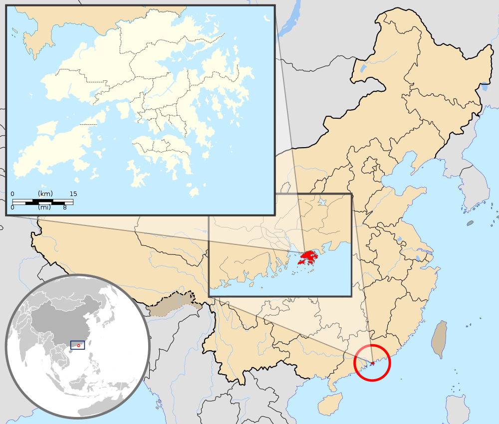
English: Map showing Hong Kong's location in Asia, on China's south coast, and Hong Kong's 18 districts
Français : Carte de Hong Kong : situation en Asie, situation sur le littoral chinois, carte des 18 districts
中文(繁體):顯示香港在亞洲,中國南海岸和香港18區的位置的地圖 |
| Dat | (UTC) |
| Sours |
Cette image vectorielle non W3C-spécifiée a été créée avec Inkscape . |
| Zotò |
|
| Autres versions | Œuvres dérivées de ce fichier : Hebao island map.jpg |
| Cette image a été retouchée, ce qui signifie qu'elle a été modifiée par ordinateur et est différente de l'image d'origine. Liste des modifications : Combination, color correction. L'image d'origine se trouve ici : China Hong Kong.svg:
|
Sa fiché disponnib soulon tèrm-yan di lisans-a Creative Commons Attribution - Pataj ké Menm Kondisyon-yan 3.0 (pa transpozé).
Latribisyon: GFDL
- Ou lib :
- di patajé – di kopyé, distribwé é transmèt sa òv
- d’adapté – di modifyé sa zòv
- Anba kondisyon-yan swivant :
- patèrnité – Ou divèt bay lenfòrmasyon-yan ki apropriyé asou zotò-a, bay roun yannaj bò lisans-a, épi endiké si i ganyen modifikasyon-yan ki nòv. Ou pouvé fè sa pa tout mwéyen ki rézonnab, men pa di roun mannyè ki ka sigjéré ki zotò-a ka soutni ou oben ka aprouvé itilizasyon-an ki ou ka fè ké li.
- pataj kou li fika – Si ou ka modifyé, transfòrmen, oben bazé oukò asou sa zòv, ou divèt distribiyé ou kontribisyon anba menm lisans-a oben roun lisans ki konpatib ké sa-a di lorijinal.
Journal des téléversements d’origine
This image is a derivative work of the following images:
- File:Hong_Kong_Location.svg licensed with PD-self
- 2008-08-27T13:27:11Z Joowwww 1270x640 (234741 Bytes) a few minor tweaks
- 2008-08-27T13:18:03Z Joowwww 1270x640 (234389 Bytes) new version: more detailed, colours are standard with most other locator maps
- 2008-04-20T13:54:51Z Joowwww 1270x640 (79729 Bytes) reduced height, removed map border and added rivers and hk's maritime border
- 2008-04-09T11:31:22Z Joowwww 1270x977 (66085 Bytes) {{Information |Description=A map showing Hong Kong's location in Asia, in China and on China's south coast. |Source=self-made |Date=2008-04-09 |Author= [[User:Joowwww|Joowwww]] |Permission={{PD-self}} |other_versions= }} {{Cr
- File:Map_of_Hong_Kong_18Districts_ZH.svg licensed with Cc-by-sa-3.0, GFDL
- 2008-07-05T21:14:26Z Moddlyg 1454x1083 (381097 Bytes) == Summary == {{Information |Description={{en|1=Map of Hong Kong & 18 Districts (Chinese Version)}} |Source=Own work by uploader |Author={{User:Moddlyg/Sign}} |Date=2008/7/6 |Permission= |other_versions= }} {{ImageUpload|ful
- 2008-07-05T20:59:35Z Moddlyg 1454x1083 (262750 Bytes) {{Information |Description={{en|1=Map of Hong Kong & 18 Districts (Chinese Version)}} |Source=Own work by uploader |Author=~~~ |Date=2008/7/6 |Permission= |other_versions= }}
- File:China_Hong_Kong.svg licensed with PD-self
- 2008-08-13T16:22:08Z Joowwww 1000x850 (212124 Bytes) added missing laos/vietnam border
- 2008-05-14T11:14:46Z Joowwww 1000x850 (210515 Bytes) {{Information |Description=An SVG map of China with Hong Kong special administrative region highlighted and circled Legend:[[Image:China map legend.png]] |Source=self-made; based on CIA public domain maps: *http://www.lib.ut
Téléversé avec derivativeFX
Listorik di fiché
Kliké asou roun dat ké lèr pou wè fiché-a tèl ki li té yé pannan sa tan-an.
| Dat ké lèr | Vignèt | Dimansyon | Itilizatò | Koumantèr | |
|---|---|---|---|---|---|
| atchwèl | 22 sèptanm 2019 à 18:33 | | 1 000 × 850 (703 kio) | En rouge | added map scale, for the higher resolution sub-picture |
| 14 mè 2015 à 04:57 |  | 1 000 × 850 (686 kio) | Flappiefh | Fixed colour of Haïnan. | |
| 5 mars 2010 à 15:40 |  | 1 000 × 850 (685 kio) | Pethrus | {{Information |Description={{en|1=Map showing Hong Kong's location in Asia, on China's south coast, and Hong Kong's 18 disctricts}} {{fr|1=Carte de Hong Kong : situation en Asie, situation sur le littoral chinois, carte des 18 disctricts}} |Source=*[[:Fil |
Litilizasyon di fiché
Paj ki ka swiv ka itilizé sa fiché :
Lizaj global di fiché
Ròt wiki-ya ki ka swiv ka itilizé sa zimaj :
- Litilizasyon asou ami.wikipedia.org
- Litilizasyon asou as.wikipedia.org
- Litilizasyon asou azb.wikipedia.org
- Litilizasyon asou bh.wikipedia.org
- Litilizasyon asou bo.wikipedia.org
- Litilizasyon asou br.wikipedia.org
- Litilizasyon asou cbk-zam.wikipedia.org
- Litilizasyon asou dty.wikipedia.org
- Litilizasyon asou dz.wikipedia.org
- Litilizasyon asou en.wikipedia.org
- Litilizasyon asou fi.wikipedia.org
- Litilizasyon asou fr.wikipedia.org
- Litilizasyon asou fr.wikinews.org
- Litilizasyon asou fr.wiktionary.org
- Litilizasyon asou fur.wikipedia.org
- Litilizasyon asou gn.wikipedia.org
- Litilizasyon asou incubator.wikimedia.org
- Litilizasyon asou io.wikipedia.org
- Litilizasyon asou it.wikipedia.org
- Litilizasyon asou ja.wikipedia.org
- Litilizasyon asou li.wikipedia.org
- Litilizasyon asou lld.wikipedia.org
- Litilizasyon asou lo.wikipedia.org
- Litilizasyon asou mad.wikipedia.org
- Litilizasyon asou mai.wikipedia.org
Wè davantaj asou litilizasyon global-a di sa fiché.