
Fiché:Europe 1740 en.png

Tay di sa apèrsou : 800 × 570 piksèl. Ròt rézolisyon : 320 × 228 piksèl | 640 × 456 piksèl | 1 024 × 730 piksèl | 1 280 × 913 piksèl | 2 560 × 1 825 piksèl | 3 872 × 2 761 piksèl.
Fiché d’orijin (3 872 × 2 761 piksèl, tay di fiché : 1,25 Mio, tip MIME : image/png)
_en.png)
.png)
.jpg)
Dèskripsyon
| Dèskripsyon |
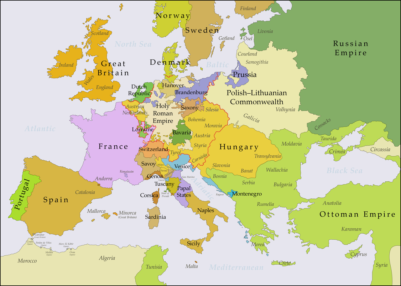
English: This map shows Europe in the years between the 1739 Treaty of Belgrade (the end of the Austro–Turkish War (1737–39)) and the beginning of the War of the Austrian Succession in 1740. The red line marks the borders of the Holy Roman Empire. The work was created with Inkscape and is mainly based on a map in: Putzger - Historischer Weltatlas, Berlin 1990, 78 pp. |
| Dat | |
| Sours | Travay pésonnèl, based on File:Europe 1748-1766 en.png |
| Zotò | Bryan Rutherford |
Kondisyon di litilizasyon
Moi, en tant que détenteur des droits d’auteur sur cette œuvre, je la publie sous la licence suivante :
Ce fichier est sous la licence Creative Commons Attribution – Partage dans les Mêmes Conditions 4.0 International.
- Ou lib :
- di patajé – di kopyé, distribwé é transmèt sa òv
- d’adapté – di modifyé sa zòv
- Anba kondisyon-yan swivant :
- patèrnité – Ou divèt bay lenfòrmasyon-yan ki apropriyé asou zotò-a, bay roun yannaj bò lisans-a, épi endiké si i ganyen modifikasyon-yan ki nòv. Ou pouvé fè sa pa tout mwéyen ki rézonnab, men pa di roun mannyè ki ka sigjéré ki zotò-a ka soutni ou oben ka aprouvé itilizasyon-an ki ou ka fè ké li.
- pataj kou li fika – Si ou ka modifyé, transfòrmen, oben bazé oukò asou sa zòv, ou divèt distribiyé ou kontribisyon anba menm lisans-a oben roun lisans ki konpatib ké sa-a di lorijinal.
Listorik di fiché
Kliké asou roun dat ké lèr pou wè fiché-a tèl ki li té yé pannan sa tan-an.
| Dat ké lèr | Vignèt | Dimansyon | Itilizatò | Koumantèr | |
|---|---|---|---|---|---|
| atchwèl | 15 jwiyé 2018 à 18:49 | | 3 872 × 2 761 (1,25 Mio) | Bryanrutherford0 | Added the Ionian Islands, made the Duchy of Milan a Habsburg possession |
| 9 jwiyé 2018 à 23:28 |  | 3 872 × 2 761 (1,25 Mio) | Bryanrutherford0 | Added Comtat Venaissin and redrew borders of Neuchâtel, Bishopric Basel, and Montbéliard | |
| 2 ògtòb 2017 à 21:39 |  | 3 872 × 2 761 (1,25 Mio) | Bryanrutherford0 | Transferred control of Saaremaa and Hiiumaa to Russia (1721 Treaty of Nystad) | |
| 24 out 2017 à 09:50 |  | 3 872 × 2 761 (1,25 Mio) | Bryanrutherford0 | Removed Prussian East Frisia (acquired 1744) | |
| 23 out 2017 à 17:17 |  | 3 872 × 2 761 (1,25 Mio) | Bryanrutherford0 | User created page with UploadWizard |
Litilizasyon di fiché
Paj ki ka swiv ka itilizé sa fiché :
Lizaj global di fiché
Ròt wiki-ya ki ka swiv ka itilizé sa zimaj :
- Litilizasyon asou azb.wikipedia.org
- Litilizasyon asou bg.wikipedia.org
- Litilizasyon asou ca.wikipedia.org
- Litilizasyon asou cs.wikipedia.org
- Litilizasyon asou de.wikipedia.org
- Litilizasyon asou el.wikipedia.org
- Litilizasyon asou en.wikipedia.org
- Litilizasyon asou es.wikipedia.org
- Litilizasyon asou fa.wikipedia.org
- Litilizasyon asou fi.wikipedia.org
- Litilizasyon asou fr.wikipedia.org
- Litilizasyon asou he.wikipedia.org
- Litilizasyon asou id.wikipedia.org
- Litilizasyon asou it.wikipedia.org
- Litilizasyon asou ja.wikipedia.org
- Litilizasyon asou lv.wikipedia.org
- Litilizasyon asou pt.wikipedia.org
- Litilizasyon asou ru.wikipedia.org
- Litilizasyon asou sr.wikipedia.org
- Litilizasyon asou zh.wikipedia.org