
Fiché:Germanic tribes (750BC-1AD).png
Pa di pli rot rézolisyon disponnib.
Germanic_tribes_(750BC-1AD).png (537 × 376 piksèl, tay di fiché : 10 kio, tip MIME : image/png)
.png)
Dèskripsyon

|
Une version vectorielle de cette image existe, dans le format « SVG ». Si elle n’est pas inférieure, elle devrait être utilisée à la place de la présente version pour des affichages en plus grandes dimensions ou nécessitant une meilleure résolution.
File:Germanic tribes (750BC-1AD).png → File:Germanic tribes settlements 750BC-1AD.svg
Pour plus d’informations sur les images vectorielles, consultez la page de transition de Commons vers le format SVG. Voir aussi les informations à propos de la manière dont le logiciel MediaWiki gère les images au format SVG. |
 |
| Dèskripsyon |
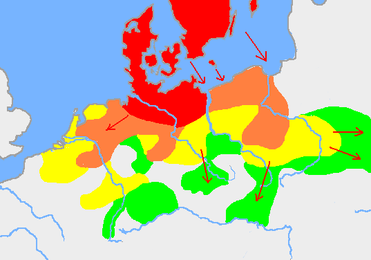
English: Based on p. 108 in the Penguin Atlas of World History, volume 1, from the Beginning to the Eve of the French Revolution. 1988. ISBN 0-14-051054-0. Note that the map assumes that the Nordwestblock was Germanized before 500 BC. This is uncertain; alternative proposals hold that the area near the mouths of the Rhine came under a Germanic superstate only in the 1st century BC.
The map is drawn on en:User:Dbachmann's blank map: en:Image:Europe plain rivers.png Settlements before 750 bc
New settlements by 500 bc
New settlements by 250 bc
New settlements by ad 1
Archived copy of a version of the original map. |
| Dat | 21 janvyé 2007 (date de téléversement originale) |
| Sours | Transféré de en.wikipedia à Commons. |
| Zotò | Berig sur Wikipédja anglais |
see also Image:Pre Migration Age Germanic.png
Kondisyon di litilizasyon
I, Berig, en tant que détenteur des droits d’auteur sur cette œuvre, la publie sous les licences suivantes :

|
Ou gen pèrmisyon-an di kopyé, distribiyé ké modifyé sa dokiman soulon tèrm-yan di GNU Free Documentation License vèrsyon 1.2 oben tout vèrsyon iltèryò ki pibliyé pa Free Software Foundation, san sègsyon ki inaltérab, san tègs di pronmyé paj di kouvèrtir ké san tègs di dannyé paj di kouvèrtir. Oun lègzanplèr di lisans-a sa enkli annan sègsyon-an ki entitilé GNU Free Documentation License. |
| Sa fiché disponnib soulon tèrm-yan di lisans-a Creative Commons Attribution - Pataj ké Menm Kondisyon-yan 3.0 (pa transpozé). | ||
| Latribisyon: I, Berig | ||
| ||
| Ce bandeau de licence a été ajouté à ce fichier dans le cadre de la procédure de mise à jour des licences des images sous GFDL. |
Ce fichier est disponible selon les termes de la licence Creative Commons Attribution 2.5 Générique.
Latribisyon: I, Berig
- Ou lib :
- di patajé – di kopyé, distribwé é transmèt sa òv
- d’adapté – di modifyé sa zòv
- Anba kondisyon-yan swivant :
- patèrnité – Ou divèt bay lenfòrmasyon-yan ki apropriyé asou zotò-a, bay roun yannaj bò lisans-a, épi endiké si i ganyen modifikasyon-yan ki nòv. Ou pouvé fè sa pa tout mwéyen ki rézonnab, men pa di roun mannyè ki ka sigjéré ki zotò-a ka soutni ou oben ka aprouvé itilizasyon-an ki ou ka fè ké li.
Ou pouvé chwézi roun di sa lisans-ya.
Journal des téléversements d’origine
La page de description originale était ici. Tous les noms d'utilisateur qui suivent se rapportent à en.wikipedia.
- 2007-01-21 10:52 Berig 537×376×8 (18448 bytes) Based on p. 108 in the Penguin Atlas of World History, volume 1, from the Beginning to the Eve of the French Revolution. 1988. The map is drawn on [[User:Dbachmann]]'s blank map: [[:Image:Europe plain rivers.png]]
Listorik di fiché
Kliké asou roun dat ké lèr pou wè fiché-a tèl ki li té yé pannan sa tan-an.
| Dat ké lèr | Vignèt | Dimansyon | Itilizatò | Koumantèr | |
|---|---|---|---|---|---|
| atchwèl | 16 févriyé 2009 à 21:34 | | 537 × 376 (10 kio) | Disposable.Heroes | pngcrush |
| 11 mars 2007 à 14:17 |  | 537 × 376 (18 kio) | R9tgokunks | {{Information |Description=Based on p. 108 in the Penguin Atlas of World History, volume 1, from the Beginning to the Eve of the French Revolution. 1988. ISBN 0-14-051054-0 The map is drawn on en:User:Dbachmann's blank map: [[:en::Image:Europe plain | |
| 11 févriyé 2007 à 17:17 |  | 537 × 376 (18 kio) | Electionworld | {{Information |Description=Based on p. 108 in the Penguin Atlas of World History, volume 1, from the Beginning to the Eve of the French Revolution. 1988. ISBN 0-14-051054-0 The map is drawn on en:User:Dbachmann's blank map: [[:en::Image:Europe plain |
Litilizasyon di fiché
Paj ki ka swiv ka itilizé sa fiché :
Lizaj global di fiché
Ròt wiki-ya ki ka swiv ka itilizé sa zimaj :
- Litilizasyon asou af.wikipedia.org
- Litilizasyon asou ar.wikipedia.org
- Litilizasyon asou ast.wikipedia.org
- Litilizasyon asou av.wikipedia.org
- Litilizasyon asou azb.wikipedia.org
- Litilizasyon asou bg.wikipedia.org
- Litilizasyon asou bn.wikipedia.org
- Litilizasyon asou bs.wikipedia.org
- Litilizasyon asou ca.wikipedia.org
- Litilizasyon asou ckb.wikipedia.org
- Litilizasyon asou cv.wikipedia.org
- Litilizasyon asou de.wikipedia.org
- Litilizasyon asou el.wikipedia.org
- Litilizasyon asou en.wikipedia.org
- Bastarnae
- Celts
- Germanic languages
- Germanic peoples
- History of Germany
- History of the Netherlands
- Lombards
- AD 1
- 250 BC
- Marchian
- Eastphalian language
- Proto-Germanic language
- Ruhrdeutsch
- East Germanic languages
- Talk:Germania
- Benrath line
- Lexin
- Vadstena bracteate
- Svealand dialects
- Leew Eilun Feer
- South Franconian German
- Highest Alemannic German
- Moselle Franconian language
- Stellingwarfs dialect
Wè davantaj asou litilizasyon global-a di sa fiché.
.png)
.png)